Geography

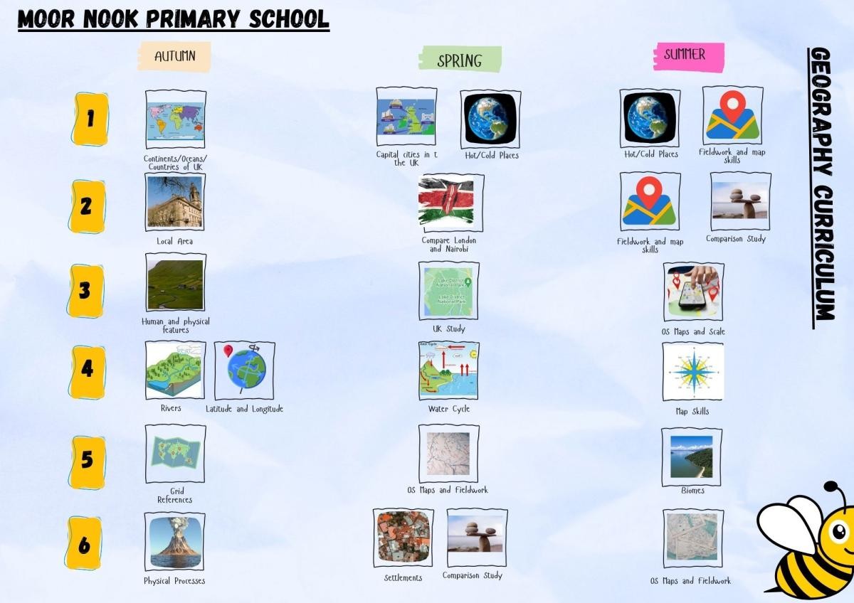
Moor Nook Primary School Geography Curriculum
 
Please find below geography curriculum.
Geography Curriculum Document
Our Vision for Geography
Statement of Intent
Geography provides a purposeful means for exploring, appreciating and understanding the world in which we live. Through our teaching of Geography, we must support and encourage our pupils, of Moor Nook, to develop an understanding and knowledge of the ‘big wide world’ and most importantly, their place and significance in it. It is our intention to inspire a curiosity of the world and the people in it for our children, to promote an interest and understanding of diverse places, people, resources and natural and human environments together with a deep understanding of our Earth’s physical and human processes (2014 Primary National Curriculum in England).

Geography encourages children to learn through experience. This is planned at Moor Nook to be achieved through practical and fieldwork learning experiences. We believe it is important to build a geographical curriculum that endorses the importance for outdoor learning to build a curiosity for learning. We believe this will help them to know more, remember more and understand more.

At Moor Nook Primary, we intend to equip our children with the skills to become independent learners. Geography lends itself to be an investigative subject, therefore provoking geographical questions from our children. When our children ask their own thought-provoking questions, we believe they are taking steps to becoming independent learners.
Aims To inspire pupils’ curiosity to discover more about the world
To ensure children know the location of the world’s different continents, countries, cities, seas and oceans.
To use correct terminology when teaching to build on children’s subject specific terminology.
To develop in children the skills of interpreting a range of sources of geographical information, including maps, diagrams, globes,
aerial photographs and live data.
To help children understand how the human and physical features of a place shapes its location and can change over time.
To provide opportunities to study mathematics across the curriculum through geography lessons.
EYFS ELG: People, Culture and Communities
Children at the expected level of development will:
Describe their immediate environment using knowledge from observation, discussion, stories, non-fiction texts and maps.
Know some similarities and differences between different religious and cultural communities in this country, drawing on their experiences and what has been read in class.
Explain some similarities and differences between life in this country and life in other countries, drawing on knowledge from stories, non-fiction texts and – when appropriate – maps.
ELG: The Natural World
Children at the expected level of development will:
Explore the natural world around them, making observations and drawing pictures of animals and plants.
Know some similarities and differences between the natural world around them and contrasting environments, drawing on their experiences and what has been read in class.
Understand some important processes and changes in the natural world around them, including the seasons and changing states of matter.
  Locational and place knowledge Human and physical geography Mapping Fieldwork
Year 1
To name and locate some places in their locality.
To name and locate the world’s seven continents and five oceans.
To name, locate and identify characteristics of the four countries and capital cities of the UK and surrounding seas.


To identify the location of hot and cold areas of the world in relation to the Equator and the North and South Poles.
To describe places and features using basic geographical vocabulary.
To express their views on features in their environment.


To use a range of maps, globes, atlases and images such as aerial photographs.
To locate land and sea on maps.
To know that symbols mean something on maps.
To draw a simple map.


To use simple fieldwork and observational skills when studying the geography of their school and its grounds
To use aerial photographs to recognise landmarks
To use locational and directional language to describe features and routes – left, right, forwards, backwards.
  
Year 2 
To name and locate significant places in their locality, the UK and the wider world.
To understand geographical similarities and differences through a study of a small area of the UK.
To understand geographical similarities and differences through a study of a small area of a non-European study.


To identify seasonal and daily weather patterns in the United Kingdom.
To describe places and features using simple geographical language.


To use a range of sources such as maps, globes, atlases and aerial photos to identify features and places as well as follow routes.
To devise a simple map.
To use and construct symbols in a key.
To use simple compass directions (N S E W).
 
To develop simple fieldwork and observational skills when studying the geography of their school and local environment.
To identify seasonal and daily weather patterns.


Year 3 
To name and locate a
wider range of places
in their locality, the UK and the wider
world.
To name and locate counties and cities of the UK, geographical regions and their identifying human
and physical characteristics, key topographical
features (including hills, mountains,
coasts and rivers) and land use patterns; understand how some of these aspects have changed over time.
To locate the world’s countries, using maps
to focus on Europe (including Russia) concentrating on environmental regions, key physical and human characteristics, countries and major cities.
To identify the position and significance of latitude, Equator, Northern Hemisphere and Southern Hemisphere, Arctic and Antarctic Circle.
To understand geographical similarities and differences through
the study of human
and physical geography of a region of the UK.
To use geographical language to describe some aspects of human and physical features and patterns.
To make observations about how places and features change over time.


To use a range of sources including digital maps, atlases, globes and satellite images to research and present
geographical information.
To use maps at more than one scale.
To use 4 figure grid references.


 To observe, record and name geographical features in their local environments.


Year 4 
To name and locate
an increasing range
of places in their locality, the UK and
wider world including some globally
significant features.
To locate the world’s
countries, using maps
to focus on Europe (including Russia) concentrating on environmental regions, key physical and human
characteristics, countries
and major cities.
To name and locate
countries and cities of the UK, geographical regions and their identifying human and physical characteristics, key topographical features (including hills, mountains, coasts and rivers) and land use patterns; understand
how some of these aspects have changed over time.
To understand geographical
similarities and differences through
the study of human
and physical geography of a region in a
European country.
 
To use geographical language to identify and explain some aspects of human and physical features and patterns.
To describe how  some features or places change and the links between people and environments.


To use a range of sources including digital and Ordnance survey maps, atlases, globes and satellite images to research geographical information.
To recognise some standard OS symbols on maps.
To use the 8 points of a compass.


To observe, record, name and explain physical and human features of the environment.
To make links between features observed to those on maps and aerial photos.


Year 5
To name and locate
an increasing range
of places in the world including globally and topically significant features and events.
To name and locate countries and cities of the UK, geographical regions and their identifying human
and physical characteristics, key topographical features (including hills, mountains, coasts and rivers) and land use patterns; understand how some of these aspects have changed over time.
To locate the world’s countries, using maps
to focus on South America concentrating
on environmental regions, key physical
and human characteristics,
countries and major cities.
Identify the position
and significance of longitude, latitude, Equator, Northern Hemisphere and Southern Hemisphere, Arctic and Antarctic Circle, the Tropics of Cancer and Capricorn.
To understand geographical
similarities and differences through the study of a human and physical geography of
a region in South America.
 
 
To use geographical language to identify and explain key aspects of human and physical features as well as links and interactions between people, places and environments.
To understand how and why some features or places are similar or different and how and why they change.


To use a range of maps and other sources of geographical information and begin to select the most appropriate for the task.
To use 6 figure grid references, symbols and keys when locating places and features.


To observe, measure and record human and physical features using a range of methods including sketch maps, plans, graphs and digital technologies


Year 6
Name and locate an extensive range of
places in the world including globally and topically significant events.
Identify the position
and significance of longitude, latitude, Equator, Northern Hemisphere and Southern Hemisphere, Arctic and Antarctic Circle, the Tropics of Cancer and Capricorn and the Prime Meridian and time zones.
To recognise patterns in human and physical features and understand some of the conditions, processes or changes that influence these patterns.
To explain some links and interactions between people, places and environments.
 
To interpret a wider range of geographical information and maps including scale, thematic and digital maps.
To recognise an increasing range of Ordnance survey symbols.


To use a range of numerical and quantitative skills to analyse, interpret and present data collected from fieldwork observations, measurements and recordings.